Bridging Technology and Ecology
Services
Human applications
In a world constantly molded by human action, remote sensing offers invaluable insights into complex environments. From agricultural assessments to urban development tracking and air pollution, Hub-Terra’s expertise enables policymakers, researchers, and businesses to make data-driven decisions.
Aquatic and Hydrological Applications
Water is the lifeblood of ecosystems, and its management is critical in times of climate volatility. Through high-precision remote sensing techniques, we monitor groundwater levels, benthic habitats, river morphology, and more. Our services empower stakeholders to enact effective and sustainable water management practices.
Terrestrial Applications
Forests, plains, and mountains are increasingly subject to human influence. We employ advanced remote sensing techniques to monitor phenomena like forest degradation, deforestation, and land cover changes. With Hub-Terra’s services, sustainable land management is not just possible; it’s effective and efficient.
Conservation Applications
Our remote sensing capabilities extend beyond immediate human concerns, taking into account the non-human life that shares our planet. Our services provide critical data for conservation applications, including mapping agricultural intensification in landscapes outside protected areas.
Case Studies
Air Pollution and Population Exposure in Madrid
Hub-Terra extends its geospatial expertise into understanding one of the most pressing urban challenges: air pollution. Through our advanced algorithms and state-of-the-art technologies, we are able to quantify, visualize, and analyze the quality of air in urban landscapes. Our work is particularly relevant in the context of Madrid—a city at the intersection of rich history and rapidly evolving modernity.
Air pollution isn’t just about hazy skies; it’s about public health, quality of life, and environmental justice. Using satellite data, we sought to understand the air pollution levels in Madrid and how they intersect with population distribution.
Data set used:
1. FAO/GAUL Administrative Units
2. Gridded Population of the World Version 4
3. Sentinel-5P NO2 offline product
Technologies Used:
1. Earth Engine Code Editor
2. Python for data analysis
3. JavaScript for UI elements
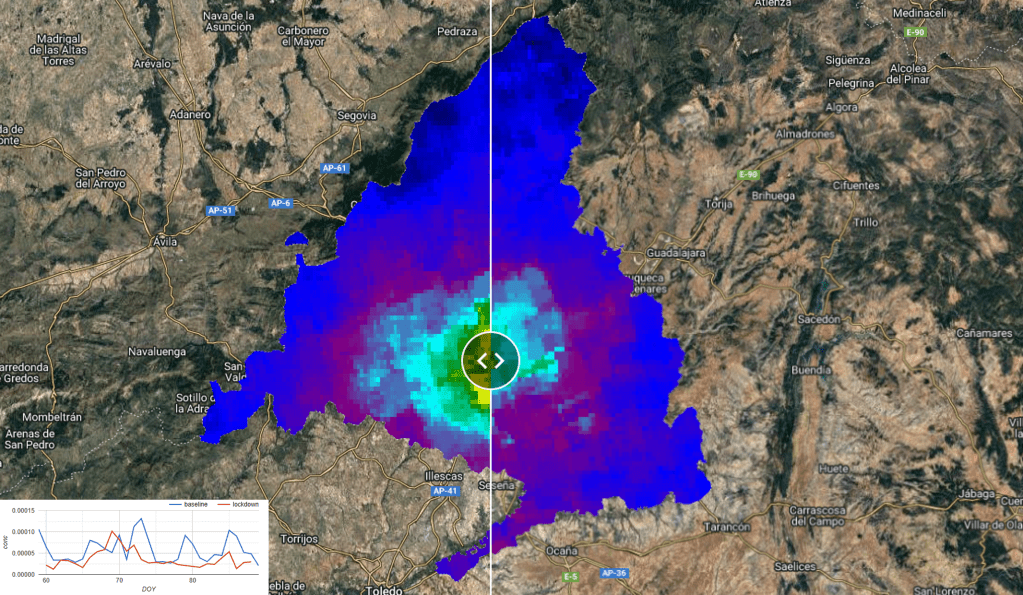
We implemented advanced cloud masking techniques to filter out noise and employed analytical algorithms to calculate the mean concentration of NO2. By comparing baseline data with the lockdown period, we could observe noticeable changes in pollution levels.
Areas with higher population density also showed elevated levels of NO2, prompting concerns about long-term health impacts. The lockdown period of 2020 saw a significant decrease in NO2 levels, indicating the potential for urban environments to recover quickly under the right conditions. These findings can inform local governments in designing targeted interventions for air quality improvement.
Our robust methodology and real-time analysis capabilities make Hub-Terra a reliable partner for policymakers, urban planners, and environmental organizations alike. As we continue to fine-tune our algorithms and expand our dataset, we remain committed to offering actionable insights for a more sustainable and healthier urban life.
Want to be part of our journey? Then let’s talk
Precision Agriculture in an U.S. County
The area of interest in this study was defined using the TIGER/2018/Counties data set on Google Earth Engine, with a focus on a specific county. Landsat 7 and Landsat 8 imagery for the year 2020 were utilized. We applied various filters to exclude undesirable features such as clouds, snow, and water bodies from the images. The Green Chlorophyll Vegetation Index (GCVI) was employed as an additional layer for robust crop type recognition. We utilized a second-order harmonic regression model by employing the ‘ee.Reducer.linearRegression’ function to fit the time series of GCVI values. These harmonic coefficients were then used as inputs to a Random Forest algorithm for crop type classification.
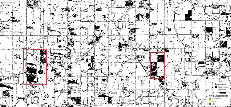
The map visually represents the correlation between our model’s predictions and the ground truth labels provided by the Cropland Data Layer (CDL). White pixels correspond to areas where our model agreed with the CDL, whereas black pixels highlight regions of disagreement. Notably, errors were primarily observed at field boundaries and occasionally within fields.
This study confirms the effectiveness of leveraging remote sensing technologies for crop-type classification. While the model performed admirably, there were some errors mostly occurring at field boundaries. These could potentially be minimized in future iterations by incorporating additional vegetation indices or employing more advanced machine-learning algorithms.
The results affirm the viability of remote sensing as a tool for modern agriculture, offering practical benefits for land managers, agronomists, and policy-makers aiming for sustainable and efficient farming practices. Thus, this case study stands as a promising proof-of-concept, heralding the broader possibilities that geospatial technologies present for agricultural management.
Ask for a demo
Actionable Insights, Unparalleled Detail
Our unique approach involves not just data collection but also expert analysis and integration into practical applications. It’s not enough to know what is happening; Hub-Terra’s mission is to use that knowledge for actionable change.
J. Bernal
Through our comprehensive remote sensing services, we are not just observers of the Earth’s changing conditions; we are active contributors to its sustainable management and conservation.
D. Bello
Let’s build something great together.
Hub-Terra
Research and Technology
29010 Málaga
Spain
©2023 Hub-Terra Investigación y Tecnología S.L. All rights reserved.
Third-party images and trademarks are the property of their respective owners and are used under permission or in accordance with their licensing terms.
Follow
