
Elevate your conservation and land management efforts with our precision modeling—where science meets actionable insight
Services
Habitat Suitability Modeling
We deploy cutting-edge statistical models to evaluate the ecological suitability of various terrains for specific species. Our models incorporate multiple environmental factors, such as climate, topography, and human activity, offering nuanced insights for land management and conservation efforts.
Species Distribution Modeling
Harness the power of predictive analytics to anticipate species distribution patterns. This solution is particularly vital for understanding the impact of climate change, habitat destruction, and invasive species.
Agent-Based Models
We specialize in agent-based models that simulate complex systems and predict interactions between various agents, whether they are animal populations or human communities. This approach provides a dynamic tool for natural resource planning and human-wildlife conflict mitigation.
Temporal Dynamics Modeling
We dive deep into the spatiotemporal patterns shaping our natural world. Utilizing high-resolution temporal data, we track seasonal variations, migration patterns, and the gradual or rapid shifts in environmental conditions like desertification. Our approach offers real-time insights and future simulations for effective land management and conservation planning.
Case Studies
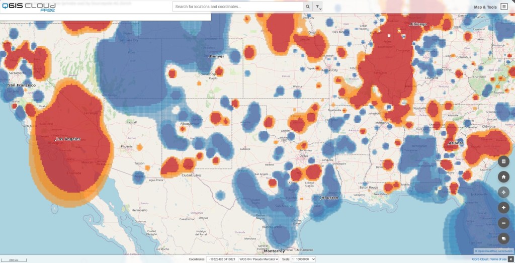
Modeling of Blue Jay Distribution in North America
The objective of this study was to identify current and potential distribution hotspots for the Blue Jay species across North America, as well as to validate these findings by comparing them to existing data from eBird.org. The methodology involved multiple stages, beginning with data collection that leveraged publicly available data sets, as the North American Breeding Bird Survey (BBS), to gain an initial understanding of the species’ distribution.
Spatial interpolation techniques, specifically kriging and Inverse Distance Weighting (IDW), were employed to predict the Blue Jay’s distribution in areas where data were missing or sparse. The interpolation model successfully filled these data gaps, producing a comprehensive distribution map of Blue Jays across North America. Further depth was added to this analysis through the application of the Getis-Ord Gi algorithm. This spatial clustering technique was utilized to identify statistically significant hotspots and coldspots in the Blue Jay distribution.
The tools used for this spatial analytics and visualization were primarily QGIS for GIS-based tasks and Python for data preprocessing and statistical analyses. The results were illuminating. Not only did the application of the Getis-Ord Gi algorithm reveal significant clustering in certain regions, identifying them as potential hotspots for Blue Jays, but a comparison with existing eBird data also confirmed the validity of our model. Moreover, our analysis highlighted previously unrecognized potential areas for the Blue Jay species in the western and northwestern parts of North America.
These findings have considerable practical implications. For one, they provide valuable input for conservation initiatives that aim to protect and sustain the Blue Jay population. Land managers can also use this data to make informed decisions on land use and allocation. Additionally, policymakers can integrate these findings into broader environmental protection strategies, ensuring that potential hotspots are shielded from excessive human activity or development.
An added dimension to this study is the interactive map we’ve developed, hosted on QGIS Cloud. Users can interact with this map to zoom into areas of interest, making the data more accessible and actionable for stakeholders involved in conservation, land management, and policy-making.
While the methods used in this study are robust and have yielded valuable insights, we acknowledge the limitations presented by the large geographic scale of North America. Future research could focus on a more regionalized approach, concentrating on areas identified as potential hotspots or coldspots. By doing so, computational resources could be utilized more efficiently, allowing for the incorporation of satellite imagery and advanced machine learning techniques in a more targeted manner. Another avenue for further research could be the inclusion of additional ecological variables, such as availability of food sources and nesting sites, to refine the habitat suitability models. These focused studies will not only be computationally more manageable but will also provide in-depth insights into specific regions, thereby adding layers of nuance to our existing models.
Want to be part of our journey? Then let’s talk
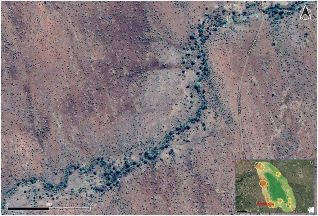
Human-Wildlife Conflict Mitigation in Limpopo National Park, Mozambique
In the wake of escalating human-wildlife conflicts, exacerbated by drought and competition for freshwater resources, our team embarked on an ambitious project within the confines of Mozambique’s Limpopo National Park. Through a rigorous methodological approach involving ensemble modeling techniques, we assessed the likelihood of interactions and conflicts between local human populations and three large herbivores: elephants (L. africana), buffalos (S. caffer), and hippos (H. amphibius).
Our primary objective was to identify potential hotspots for conflict, employing cutting-edge ensemble models that integrate variables such as altitude, mean temperature of the warmest month, and annual precipitation. This scientific endeavor aimed to offer insights into spatial distributions and provide invaluable data for mitigating conflicts.
The ensemble statistics showed strong performance across various metrics, including TSS (0.72-0.78), ROC (0.91-0.95), and Kappa (0.4-0.65) values. Different algorithms like Random Forest (RF), Maximum Entropy Modelling (Maxent), and Generalised Additive Models (GAM) were used, each contributing uniquely to the robustness of our models.
We discovered potential conflict zones predominantly distributed in the western half of the park, establishing these areas as requiring immediate attention. These heat maps serve as a tool for local management to concentrate their mitigation strategies, thereby aiming for a more harmonious coexistence between humans and wildlife.
The insights from this study are instrumental in informing targeted interventions and resource allocation. They also highlight the efficacy of ensemble models as invaluable tools for studying human-wildlife interactions.
This project was carried out in collaboration with IDAF-Forestry Consulting and various stakeholders. For those interested in delving deeper into our research, please consult the full Master’s Thesis on ResearchGate, explore our detailed findings on the associated story map, or book an appointment for more info.
In a world where data is abundant but actionable insights are scarce, our advanced modeling services stand as a beacon for informed, impactful decision-making in conservation and land management.
D. Bello
Let’s build something great together.
Hub-Terra
Research and Technology
29010 Málaga
Spain
©2023 Hub-Terra Investigación y Tecnología S.L. All rights reserved.
Third-party images and trademarks are the property of their respective owners and are used under permission or in accordance with their licensing terms.
Follow
